Gridded Meteorological Data: 1949-2010
Data Set: Daily 1/8-degree gridded meteorological data [1 Jan 1949 - 31 Dec 2010]. Data are posted as they are created.
Citation: If you acquire data from this web site, we request that you please acknowledge this by citing the primary reference for this, Maurer et al. (2002):
Ref: Maurer, E.P., A.W. Wood, J.C. Adam, D.P. Lettenmaier, and B. Nijssen, 2002, A Long-Term Hydrologically-Based Data Set of Land Surface Fluxes and States for the Conterminous United States, J. Climate 15, 3237-3251.
Contacts: Ed Maurer at Santa Clara University, Andy Wood at CBRFC
Data Description: The updated data were processed exactly as in the reference above with the single exception of the precipitation time-of-observation adjustment. For this updated dataset, if a meteorological station has a time of observation before noon, the precipitation is assigned to the prior day, otherwise no adjustment is made.
The links below are to files containing daily precipitation (mm/day), maximum and minimum temperature (C), and 10-m wind speed (m/s) for each 1/8-degree grid cell, grouped (using the UNIX tar command) by hydrologic area. The individual data files, (which can be extracted using tar zxvf <tar filename>) indicate the location center of the grid cell in the file name: data_<latitude>_<longitude>. Each daily data file contains columns of year, month, day, daily total precipitation, maximum temperature, minimum temperature, and average 10-meter wind speed in ascii format. If you need sub-daily interpolation of temperature, or radiative and humidity forcings as well as those listed above, the current VIC model code can be run with the OUTPUT_FORCE flag in user_def.h set to TRUE for the cells of interest, and recompiling the program.
In addition below are monthly time series of the data (for each grid cell) of the same variables (precipitation is a monthly total in mm, other variables are monthly averages), in ascii format, as indicated below.
The original data, extending from 1949-2000 are avaiilable at the UW website. Note that minor differences will exist between this updated dataset and the original 1949-2000 data, due to the one change in the processing noted above.
As of March 2011, the data have only been checked that randomly selected grid cells 1) reproduce the monthly total precipitation and monthly average temperature for the older, UW dataset, and 2) that the extended period appears plausible for P, Tmax, and Tmin. While QA/QC will be continuing, especially once the domain is completed, please alert us if you notice anything curious in this data. It has been noted that some inconsistency is evident in some locations due to station density declining for the period from 1998 onward, though all stations available through NCDC were included.
Note: it was identified that there is a spatial shift in the wind field in both the original 1949-1999 and in the updated 1/8-degree US-wide data served here. The interpolation placed the 10m winds approximately 1.5 degrees to the North and West. As these data sets are being updated at a finer resolution, no correction to these data sets are anticipated.
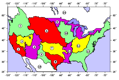
Summary of Basins:
|
Basin/Region |
Daily Data |
Monthly Data |
|
|---|---|---|---|
|
1 |
Northwest and Columbia3 |
||
|
2 |
California |
||
|
3 |
Great Basin |
||
|
4 |
Colorado River |
||
|
5 |
Rio Grande |
||
|
6 |
Missouri River2 |
||
|
7 |
Arkansas-Red |
||
|
8 |
South Central (Gulf) |
||
|
9 |
Great Lakes Drainage |
||
|
10 |
Upper Mississippi |
||
|
11 |
Lower Mississippi |
||
|
12 |
Ohio |
||
|
13 |
East Coast |
||
|
14 |
Canada (excl. Columbia) |
||
|
15 |
Mexico1,4 |
||
NetCDF format of the above are available here: daily monthly. Note monthly nc files are monthly averages of daily values for all variables.
1Thanks to Dr. Vimal Mishra of the University of Washington for updating the Mexico data and for making it available here.
2An error was found for one station and month in the Missouri Basin. Revised data was uploaded August 23 2011.
3Currently Columbia basin data only includes the US portion of the basin.
418 October 2011, it has been found that for some days there is a strong discontinuity at the border between Mexico and the US. It is likely that this is due to the distinct data sources for the US and Mexico, and the paucity of data near the border, though this remains to be verified.
Standard Disclaimer
These data are being made available to provide immediate access for the convenience of interested persons. These are believed to be reliable, though human or mechanical error remain a possibility. Therefore, there is no guarantee as to the accuracy, completeness, timeliness, or correct sequencing of the data. None of those involved in creating, processing, or distributing this information shall be responsible for any errors or omissions, or for the use or results obtained from the use of this information.
Last Updated: May 31, 2013